Go Back and Look At It Again

Hello all!


During my
time here at CCEPS, I have come across several documents that have been of
interest to me. Today, I would like to share more about one of my favorite
documents that has taught me about an event in southern Californian history
that I didn’t know about until yesterday. While working on metadata for the Imperial
Valley Records items I have scanned, I revisited the following document: “Letter
to N. W. Stowell of California Development Company from Thos. L. Woolwine.”
Stowell inquired with Woolwine about representation in the case of California
Development Company vs. the Imperial Land Company. To better understand what
this court case was talking about, I did a little research.


In previous
posts, I have talked about the Salton Sea in relation to the development of the
All-American Canal in the Imperial Valley. This canal was not, however, the
first in the region. At the turn of the century, the California Development
Company (previously known as the Colorado River Irrigation Company) built the
Alamo/Imperial Canal, which was to irrigate and provide water for the farming
communities in the Imperial and Coachella Valleys by diverting water from the
Colorado River. The Salton Sink area (what we know now as the Salton Sea) was
fertile for a short time. After heavy rains caused the Colorado River to
overflow, this higher influx of water brought more silt through the Imperial
Canal and caused blockage. This blockage led to dikes breaking, canals
overflowing, and an infrastructure disaster that completely altered the course
of history for the Imperial and Coachella Valleys. Massive flooding destroyed
farms, submerged a town, and changed the environmental face of the Salton area.
The silt from the Colorado River poured into the Salton Sink area and
eventually formed what we now call the Salton Sea. The California Development Company
faced several lawsuits from farmers and other land companies in the area and
eventually went bankrupt. In 1911, the Imperial Irrigation District formed
through a collective of farmers and local citizens, and from this year forward,
this organization managed the development of water infrastructure in the area. With
the context of this incident in mind, this helps explain some of the fears facilitating
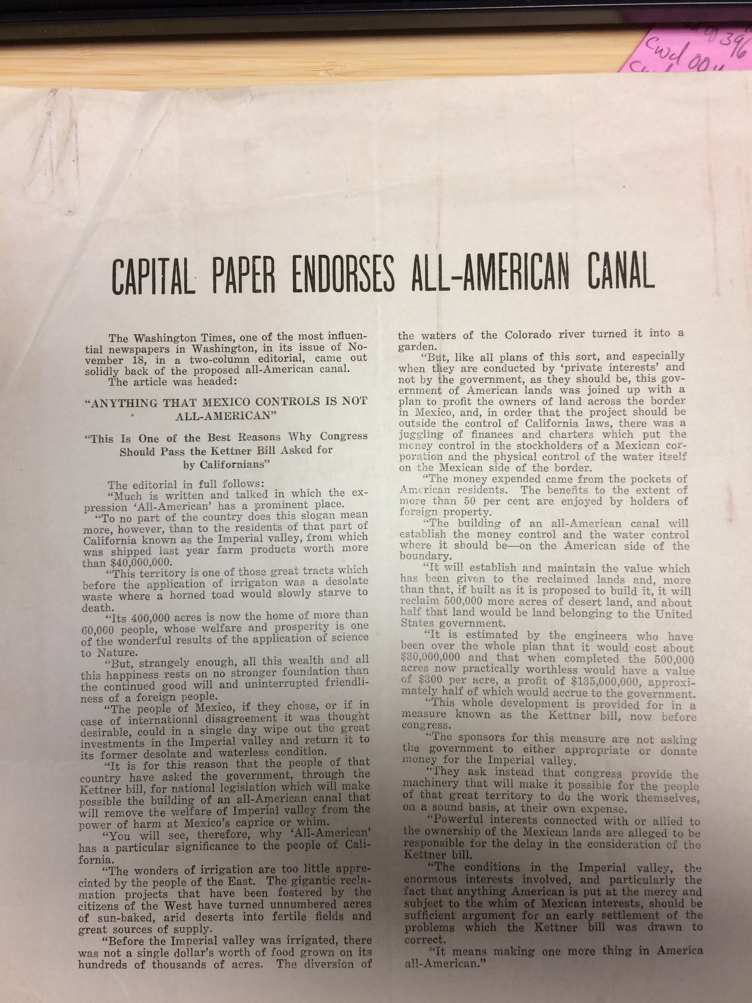
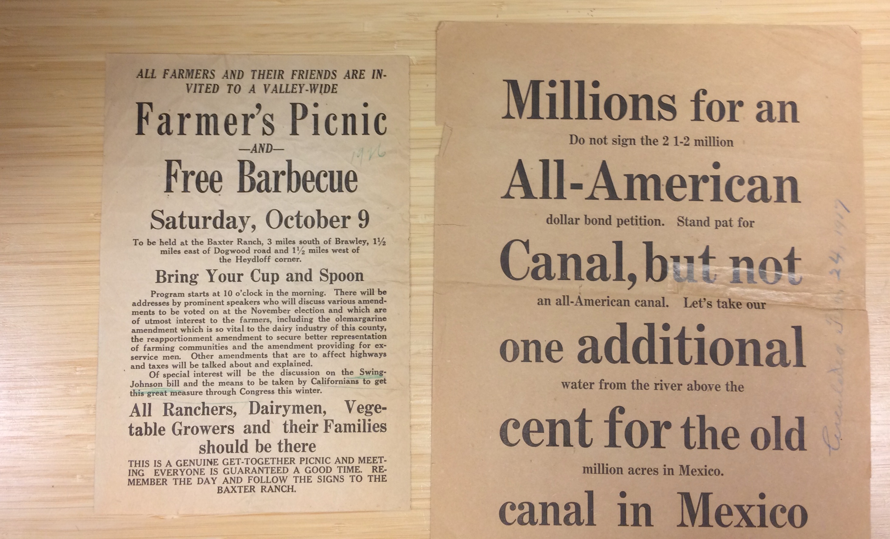
the creation of the All-American Canal. The aggressive advertising, including
xenophobia against Mexico, and calls to rally around the support of the
financing bills in Congress have a historical context with this in mind. Citizens
of the Imperial and Coachella Valleys needed water, but they needed the canal
to be built to combat flooding.


The
documents tell a story, especially when placed in conversation with each other.
By digitizing these documents, hopefully other archives patrons will be able to
read through the documents I have had the pleasure of looking over while
digitizing.


Normal
0

false
false
false

EN-US
X-NONE
X-NONE

/* Style Definitions */
table.MsoNormalTable
{mso-style-name:”Table Normal”;
mso-tstyle-rowband-size:0;
mso-tstyle-colband-size:0;
mso-style-noshow:yes;
mso-style-priority:99;
mso-style-parent:””;
mso-padding-alt:0in 5.4pt 0in 5.4pt;
mso-para-margin-top:0in;
mso-para-margin-right:0in;
mso-para-margin-bottom:10.0pt;
mso-para-margin-left:0in;
line-height:115%;
mso-pagination:widow-orphan;
font-size:11.0pt;
font-family:”Calibri”,”sans-serif”;
mso-ascii-font-family:Calibri;
mso-ascii-theme-font:minor-latin;
mso-hansi-font-family:Calibri;
mso-hansi-theme-font:minor-latin;}

Metadata Mania


Hello again
all!


This week I
have started working on metadata, which as some of my coworkers have explained
in the past, refers to subject terms and descriptive information about the
digitized items. Metadata is important in digital archives because it allows
patrons to find what they’re looking for with relative ease! Without metadata, users
would have to spend more time looking for primary sources relevant to their
research topic. Some items might be overlooked because they are too obscure or
simply become lost in the oversaturation of items.


As this is
my first day working on metadata, I am rather slow at putting all of the
information into an excel spreadsheet. As time passes and I become more
familiar with the Library of Congress subject headings that are relevant to the
California Water Documents Collection, I suspect I will be able to complete the
metadata faster.


One step I
am looking forward to with the metadata process is working with geospatial
information. We will eventually be working with the library’s resident GIS
experts in order to input geographical information into the metadata. First, we
plan on filtering the documents through text mining software to pull out
geographic information. Whenever a document cites a location such as the Salton
Sea, the text mining software will add that to a pool of locations, which we
can then translate into latitude and longitude coordinates. From there,
researchers will be able to use the metadata we provide in order to make maps
with GIS.   


I am happy
to begin learning more about the next phase of the digitization process with
these water documents. As a researcher myself, I know how important it is to
find everything relevant to a research topic–you do not want to be told you
missed something that could have been helpful. Thus, as I create the metadata,
my goal is to be as thorough as possible while also still being efficient.


Until next
time!


Normal
0

false
false
false

EN-US
X-NONE
X-NONE

/* Style Definitions */
table.MsoNormalTable
{mso-style-name:”Table Normal”;
mso-tstyle-rowband-size:0;
mso-tstyle-colband-size:0;
mso-style-noshow:yes;
mso-style-priority:99;
mso-style-parent:””;
mso-padding-alt:0in 5.4pt 0in 5.4pt;
mso-para-margin-top:0in;
mso-para-margin-right:0in;
mso-para-margin-bottom:10.0pt;
mso-para-margin-left:0in;
line-height:115%;
mso-pagination:widow-orphan;
font-size:11.0pt;
font-family:”Calibri”,”sans-serif”;
mso-ascii-font-family:Calibri;
mso-ascii-theme-font:minor-latin;
mso-hansi-font-family:Calibri;
mso-hansi-theme-font:minor-latin;}

Learn As We Go

Hello again all!


Just a short post for this week from me. I’m currently in between finishing the Imperial Valley Records and a new item, San Gabriel Spreading Grounds Investigation: Review of Haehl and Etcheverry Findings and Analysis of Conservation of Local and Other Water Supplies, Los Angeles County Flood Control District, 1955 by L. W. Jordan. 

In scanning these documents, I have learned new things about California’s water history and its relationship with other states and countries. I try to do a brief glance over of each page as I’m scanning, just so I can be familiar with the collection. I’m a history masters student, so I am more focused on looking for the socio/political/cultural aspects of these documents (see my previous blog posts for examples).

Here is an example of some socio-cultural information that I found interesting on one of the contracts found in Box 3 of the Imperial Valley Records:

gambling.PNG


No liquor and no gambling. Well that’s no fun! But also relevant for the time period. I have seen similar rhetoric in other contracts in the Imperial Valley Records as well as documents from other southern California cities having “character criteria” for workers and citizens. 

However, given the subject of these documents, much of what I see in the documents flies over my head. I am most unfamiliar with engineering and accounting jargon, which frequently comes up in schematics or contractual records. With just a basic google search, I have been able to provide myself with a better understanding of the differences between various water related infrastructure. Exposure to these terms and concepts has proved helpful. As I went through Box 1 and Box 3 of the Imperial Valley Records, terms became less unfamiliar, and I was able to piece together some sort of narrative. 

While I may not be able to digest these documents to their fullest, others who make use of the digital collection we’re creating might be able to. Maybe I can’t decipher all of what I see, but hopefully others can and will in the future!

Until next time!


Fun Finds

Hello again!

This week, I’m going to share some fun finds I’ve come across while scanning Box 3 of the Imperial Valley Records.

Blog.jpg

The item on the left advertises a picnic barbeque to gather farmers,
ranchers, and growers in the Imperial Valley area. According to the flier,
speakers (politicians and members of the Imperial Irrigation District), will
talk about the Swing-Johnson Bill and other pertinent legislation that the
citizens need to be aware of. This interested me because it speaks to how the
citizens of the Imperial Valley learned about politics happening in their area.
I also thought it was somewhat amusing how the flier has to assure that this event is a “genuine” get-together
picnic, as if to imply there’s disingenuous events being held.


The item on the right interested me because it continues the rhetoric
and local discourse surrounding the development of the All-American Canal, both
as a concept and in its implementation, which I discussed in my post last week.

1.PNG

This is a pamphlet that discusses the power industry and government control over utilities. At the end of the pamphlet, the author, in my opinion, was quite sarcastic towards his opposition, which supported the Swing-Johnson Bill which would fund the All-American Canal.

2.PNG

So maybe the Salton Sea won’t immediately flood if the Colorado River overflowed, like some proponents argued. Either way, you could say the topic of water, canals, and southern California sure made folks salty back then.

Normal
0

false
false
false

EN-US
X-NONE
X-NONE

/* Style Definitions */
table.MsoNormalTable
{mso-style-name:”Table Normal”;
mso-tstyle-rowband-size:0;
mso-tstyle-colband-size:0;
mso-style-noshow:yes;
mso-style-priority:99;
mso-style-parent:””;
mso-padding-alt:0in 5.4pt 0in 5.4pt;
mso-para-margin-top:6.0pt;
mso-para-margin-right:0in;
mso-para-margin-bottom:6.0pt;
mso-para-margin-left:41.75pt;
line-height:22.0pt;
mso-pagination:widow-orphan;
font-size:11.0pt;
font-family:”Times New Roman”,”serif”;
mso-ascii-font-family:”Times New Roman”;
mso-ascii-theme-font:minor-latin;
mso-hansi-font-family:”Times New Roman”;
mso-hansi-theme-font:minor-latin;
mso-bidi-font-family:”Times New Roman”;
mso-bidi-theme-font:minor-bidi;}

Power, Place, and Perspective

Hello all!

I would like to share with you all a few documents that caught my eye from the Imperial Valley Records, which I have been scanning for the past few weeks. These documents, in my opinion, are the sort that could launch a thousand research papers. At the same time, I’ve been thinking about the significance of the Imperial Valley’s geographic location and the power of place upon local discourse. If you recall from my blog post from last week, I showed a map of the Imperial Valley. Here it is again:

Imperial Valley.PNG
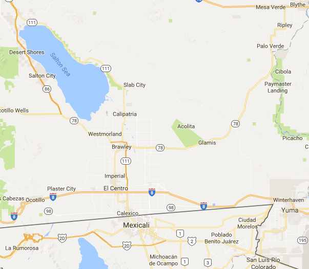
So, as you can see, it’s located on the border between southern California and Mexico. The document I’m about to describe illustrates some of the social, economic, and political power dynamics that took place at the dawn of the twentieth century in this region.

In a newspaper clipping entitled “Capital Paper Endorses All-American Canal,” the author provides the text of an editorial published in The Washington Times which endorses the construction of the All-American Canal, a water project of the Imperial Irrigation District. Thus, in the subsequent editorial
“Anything that Mexico Controls is Not All-American,” the author
encourages congress to move forward with the Kettner Bill, which would
finance the canal.
Pay attention to the rhetoric of the canal’s name. All-American.

IMG_0555.JPG
The author describes how the Imperial Valley, though beautiful, needs more water to support its $40,000,000 farming industry with over 60,000 residents. Access to water without the canal, according to the author, relied upon the people of Mexico, who if they chose, “or if in the case of international disagreement it was thought desirable, could in a single day wipe out the great investments in the Imperial Valley and return it to its former desolate and waterless condition.” An “All-American” canal would remove this threat by establishing “water control where it should be–on the American side of the boundary.”


At the end of the editorial, the author explains the penultimate reason for constructing an “All-American Canal”: “It means making one more thing in America all-American.” Sound familiar at all?

Given the geographic context of the Imperial Valley on the borderlands between California and Mexico, this editorial illustrates racial tensions in southern California that had carried over from the 1800s and continued on through the twentieth century. As a historian, this document blew me away. Not only does it shed light on the time period’s xenophobic fears and isolationist discourses, it reveals something both frustrating and illuminating as a historian: history often repeats itself in unexpected ways. 

Adventures in Summer Scanning

Hi all!

My name is Michelle. I’m a new student worker at CCEPS working on the CLIRWATER project. I am a history masters student at CGU studying post World War II California history. This is my second time working in an archival setting. I previously volunteered at the A. K. Smiley Library last summer, and to my surprise upon being hired, the A. K. Smiley Library is also participating in this new project.

Normal
0

false
false
false

EN-US
X-NONE
X-NONE

/* Style Definitions */
table.MsoNormalTable
{mso-style-name:”Table Normal”;
mso-tstyle-rowband-size:0;
mso-tstyle-colband-size:0;
mso-style-noshow:yes;
mso-style-priority:99;
mso-style-parent:””;
mso-padding-alt:0in 5.4pt 0in 5.4pt;
mso-para-margin-top:6.0pt;
mso-para-margin-right:0in;
mso-para-margin-bottom:6.0pt;
mso-para-margin-left:41.75pt;
line-height:22.0pt;
mso-pagination:widow-orphan;
font-size:11.0pt;
font-family:”Times New Roman”,”serif”;
mso-ascii-font-family:”Times New Roman”;
mso-ascii-theme-font:minor-latin;
mso-hansi-font-family:”Times New Roman”;
mso-hansi-theme-font:minor-latin;
mso-bidi-font-family:”Times New Roman”;
mso-bidi-theme-font:minor-bidi;}

This is my third week of work and I have finally dived into a collection. Currently I am working on the Imperial Valley Records, Box 1, which contains documents that relate to water issues in Imperial County, California.

As you can see in the map below, Imperial Valley is located at the southernmost part of California, bordering Mexico and southern Arizona.

Imperial Valley.PNGMost of the documents I’ve scanned so far were produced by the Imperial
Irrigation District which manages water to this day for this county.
Some of the referenced infrastructure includes canals, dams, and levees. Some documents include tables which record the amount of water moving through canals or dams, often including how much water is lost due to seepage or evaporation.

Coming into this project, I knew that water plays a key role in the development of southern California in the 20th century. However, scanning items from this collection has helped me realize the value of this project. Digitizing these water documents will of course provide future scholars a new point of view for analyzing California history. In addition, these documents could prove useful with the threat of climate change looming. Though most of California has narrowly managed to come out of the drought with this past winter’s record rain and snowfall, the drought will inevitably return. Urban planners, civil engineers, environmentalists, politicians, and everyday citizens could use these documents to uncover new solutions to old water issues.

In the mean time, I still have several more folders to work through. Next week, I’ll provide some pictures of my favorite sources from this box.

Until next time!

Michelle