Fine

Hundreds of maps, pages depicting detailed accounts of cultures, stories and renderings of peoples and landscapes, instructions on preservation, and receipts of transactions from a single man’s interest, all contained in the three boxes. Each box just bigger than the next, like an Olympic ceremony podium. All of it to be stowed away in the permanent storage facility of a university thousands of miles and hundreds of years away from the original pen, or gaze, or idea.

With the arranging, encapsulation, itemization, and data input into ArchiveSpace, the journey is more or less over. The sense of incompleteness combined with achievement and relief feels ecological. It is a notion, a feeling I haven’t felt since my landscaping days. You tidy up, organize, and present knowing that nothing is ever finished. The next set of eyes to look on the maps will be like a new leaf after years of dormancy. It is comforting and disconcerting too. What type of work I did could determine the productivity or ability of the researcher in the future.

I feel like a voyager in ways, sailing over these maps. Their wide expanse continually unfolding under me, landscapes appearing and waning, all interpretable before they vanish. Now that I’ve reached my destination, now that the journey is over, could go back?

I took what I measured. I took what I understood and attempt ways of representing what was there. The options were infinite, but good work has finitude. In the end, “fine” appears at the end, right before the credits roll. Fine indeed.
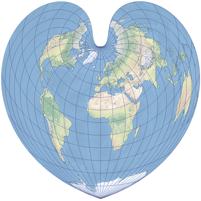
What is one man’s heart is another’s equal-area pseudoconic map projection

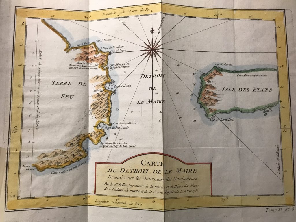
Daily, I have regular encounters with two French ghosts in the CCEPS archive. One goes by Jacques-Nicolas Bellin and the other by his successor, Rigobert Bonne. I have never seen them but their presence is certainly felt in the maps. The whimsical part of me, perhaps a state induced by a windowless room thick with time, almost believes as if they are attempting to vigil me somewhere in their maps. They ebb and flow in my temporal moments without pretext or pattern. As hydrographers, they appear mostly on the coastlines. Just as the indigenous of Terra de Fuego, the shore is the contact zone of these merging worlds. For the colonists, it was that of mooring. For me, it is the grip of a page.

Bonne is the rather quite one, though his projections, the dépôt de la guerre or modified Flamsteed, have their say in cartographic history. In other words, his work speaks for itself. The projection articulates more accurate shaping around the prime meridian and standard parallel. It is perhaps of no small note which countries that central line passes through. Everything from that Franco-Anglo focus distorts in t-shaped dimensions, in circular contortions. Really, it looks like a heart. What is one man’s heart is another’s equal-area pseudoconic map projection. In fact, the heart was invented by Claudius Ptolemy about A.D. 100 but it was Bonne who really put it on the page. With that heart comes an overabundance of Eurocentrism. In the distortions are the “false easting” and “false northing.” It probably has no intentional implications to be fair. Still every heart has its meridian.

An example of the Bonne projection

Aside from Bonne and his distortions and heart projections come discourses and identities I’d expect from French geographers in the Enlightenment. Party to the Encyclopédistes and the philosophes, Bellin was in the company of none other than the likes of Montesquieu, Voltaire, Rousseau, and Baron d’Holbach. Over the course of his career he contributed over 994 articles. He was a man not of the heart, but of the mind. A serious enlightenment figure, his transition to a more rigorous and positivistic approach in cartography impacted far more than just mapmaking. In this time, the most influential members of a burgeoning history profession depended on and were enchanted by the developments in mapmaking. With these technologies of land order was deployed to solve conflicts such as the Sykes-Picot line. France and the United Kingdom, by their own means, divyed up “the orient” by drawing a straight line across a map. This is mine. This is yours. Surely there won’t be any conflicts resulting from it later. The maps reflected in the interpretation of land and space for historians and their celebration/formations of national identity. The scientific approach to mapmaking directly engendered culture and evidenced it. Remember, geographers like Bellin were at the employ of the King and the navy. The ink was drawn from that well. Draw the lines were they may fall, but the picture I see is a mapmaking of colonial legacy in historiography.

Least to say, our conversations muddle and froth. Ironically, Bellin often complains. He had always found his mapmaking efforts tedious and a burden. In a way, I can listen to Bellin and almost empathize with him. He was caught in the machine of the Enlightenment juggernaut. Cartography was a means of survival based on a skillset. I wonder if he ever reflected on his impact. I wonder if he questioned what his maps might do. Bonne, he’s got heart, which makes me more suspicious of him. That sort of application seems unreachable. I find it more difficult to breach his passion. But we are so thick of time here in the archives. There is little light and less windows. We ebb and flow in this space with little pretext or pattern

Making Arrangements

300 some-odd maps, articles, magazine clips, receipts, and prints later, the survey’s complete. Now I’m toiling with direction. I yoke the plans.

A few days ago I was reading several articles which placed emphasis on the accessibility of material via description and order. I tried to get inside the head of a potential researcher. Who would approach this collection and why?

There were a few possible directions I could’ve gone: mapmaker, dates, regions, language, type of map, or place of production. Ultimately, it was decided between my manager and I to divide the series into maps and printed matter.

Within maps, the subseries were based off continents: South America, Africa, Southeast Asia/Pacific Islands. From there, I will focus on regions.

I do wonder how it will translate in description. English and French are the predominant languages. Do translations bode a particular value here? Of course. I feel there is something lost in combining them by region. Who produces and for what purposes would have great value in research.

There is a somewhat ironic knot to undo in the complications of homogenizing map producers based off the heterogeneity of their production.

Contours of Impression; Cartographies of Knowledge

I tend to dwell on the content of the maps. But today I had a revelation, one that may have a more of an impact on my archival efforts down the line. Today, I wondered about the sport, perhaps, or rather the technologies of the actual mapmaking. How are the prints differing? What are the processes and stylings of cartographic practice? I imagine their production is important for collectors. Somehow it was not for me until today. Maybe this was a form over function thing all along. In fact, if it wasn’t for the overwhelming focus on South America–particularly the Strait of Magellan–I would really question if I made a serious error in not recording the maps’ typology in this auditing process. Luckily, ancillary material indicates that my focus on the content is the correct approach to this.

But in that brief anxious episode, I went exploring. I wanted to chart mapmaking in the era of these maps’ production. The 18th century signaled a period shift in mapmaking. Gone were the salacious mermaids, fanged whales lunging out at hapless sailors, reptilian figures lurching over the shoulder of an unknown island spraying fire from their nose. Factuality was fore; flair to the cartouche and border. This was the beginning of Enlightenment remember. Maps served science. Everything did.

With industrialization dawning, technologies proliferated and cartographers gained access to more and more tools and skills. They had telescopes and this thing called a chronometer that would chart more accurately ones positions longitudinally. Most importantly though, came the beloved survey, a technique deployed all across Europe’s most stately nation-states. The precision of data becomes the veritable counters of knowledge production industrialized, manufactured to scale.

Derived from military practices, cartography remained highly specialized–if not even more. Technical planning of the maps involved choice of a counter interval (elevation separating contour lines, lines of constant elevation). Mapping step sequences, or operational phases, were determined by the most efficient technical procedures. A guide copy printed on several sheets of plastic coated with an opaque paint, usually yellow, imprinted these counters to be prepared for the negative engraving or scribing process. The scriber follows copy on the respective plates by engraving through the coating as an arc light can only pass through engraving scratches, which become the negatives for press plates.

Most finite lines, matrices, upon more grids of lines, some of which are 0.002 inches, or 0.05 millimeters wide, are intermediate contours engraved freehand. Yet heavier lines, the index contours engraved at 0.007 inch, required small tripods for perfect verticality. Boundaries and shorelines printed and etched on coated sheets, areas of woodland or water peeled off, leaving open windows for features. There, character can peek through the lines.

Despite these maps’ precision and multifarious means of production, only on a globe can maps retain fidelity. Maps, projected onto a flat surface as a method of production contain inevitable distortions. By light, impressions are guided by the choice of the engraver. With distortions comes perspective. What is my perspective? Perhaps its gnomonic, stereographic, or orthographic. I consider my projections in interpreting the material. I consider the contours of my impression of it. Archiving is a technology. All this psychodynamic cartography going on in the process of my task.

Trayendo El Fuego

As I’m nearing the completion of this audit of the Drundel collection, I’m beginning to wonder if it should be called “Maps and ephemera of Tierra del Fuego and others.”

Why Tierra del Fuego? It is the first time I’ve heard of this land, but certainly not the first I’ve heard of its associations: Strait of Magellan, Patagonia, Chile, Argentina. As with really any coastal region in the fertile, precolonial South Americas, it became an immediate site of extractive enterprises. This was of no shock.

Perhaps one of the more interesting facts I learned about the island was in the nationality of the renown colonial entrepreneur in the region, Julius Popper. I’ve seen his name mentioned on a few of the maps, but hadn’t taken great note of them. Unlike most of the conquistadors, Popper was Romanian. Originally employed as a telegrapher in Chile, he set his sites on prospecting the little known metals of the island.

In the late nineteenth century, it was here he encountered the Selk’nam tribe and sponsored a genocide that lasted almost a decade. The tribe, once 4,000 individuals, were reduced to 500.

The Selk’nam were one of three tribes on Tierra del Fuego. They were hunter-gatherers and primarily situated in the northeast region, referred to as Onas by the other tribes. In the late nineteenth century, cattle farmers, gold seekers, and farmers instigated their extermination by means as brutal as deportation, hunting of members, and alcohol (Gardini, 647). “The pen hesitates to describe this systematic extermination,” writes Austrian Ethnologist Gusinde.

Gusinde himself, regarding them a “magnificent race,” was more than willing to ship their skulls to anthropological museums in Europe under the banner of science. But it was ultimately the cattle ranchers, favored by local authorities, who proposed and carried out the genocide with impunity.

Tierra del Fuego itself boasts surreal and enchanting geographical features. Each of the drawings and photos captured of the area portray a cinematic panorama without compare.

These astounding features being shaped by and characterized by the Andrean orogeny supplies a somewhat uncanny analogy to its cultural history and my role as a researcher. It is this idea of distance. I wonder often how distance can so readily lead to violence.

The name “Tierra del Fuego” derives purportedly from early conquistadors observing bonfires on the shoreline as they passed through the Strait of Magellan. The reports are that these indigenous tribes were staging an attack. What if it was a greeting? In fact, it probably had nothing to do with the colonizers at all. What if the the shore remained in shadow, never drawing the eye of the colonizers? There’s a melancholy in great events, both horrific and beatific, made probable when distance is brought to light.

Sources:

Gardini, Walter. “Restoring the Honour of an Indian Tribe-Rescate de Una Tribu.” Anthropos 79, no. 4/6 (1984): 645–47. http://www.jstor.org/stable/40461884.

Knowledge: A Map, An Island

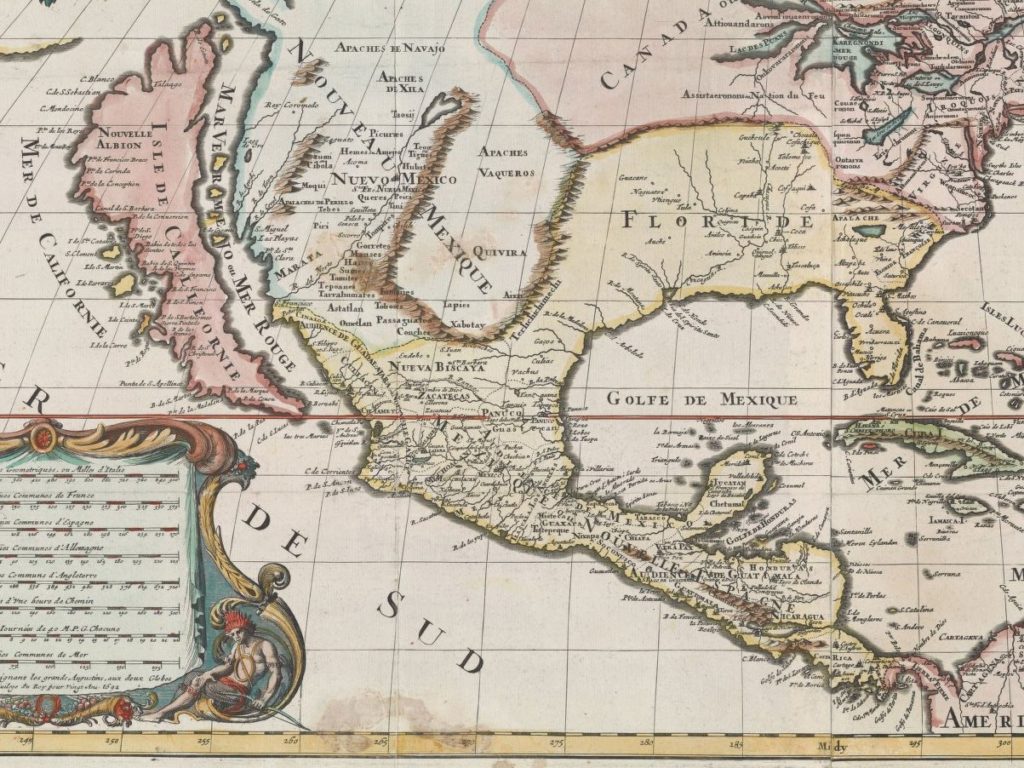
For about 100 years, sometime after 1622, mapmakers portrayed California as an island. Among the history of cartographic errors this is always one enjoyed in US scholarship–becoming a comedic synecdoche in CA’s political history. Uniquely, and perhaps adding to the enigma of the story, the error has an origin. The culprit was Juan de la Fuca.

There is perhaps nothing entirely new in this bit of trivia. But in studying many of these maps, I am often left astounded by their detail. I fathom at the intricate and precise nature of these hand-drawn, works of art.

Without access to anything remotely similar to our cartographic technologies, how could they be done so well? I assume that many of the maps are palimpsest; or they build on a former version of the area. They are recursive. Like a sculpture fashioned over generations or by a multitude of hands, these maps arrive at a better understanding of the land through collective, historical paradox of iteration and revision.

Philosophically, this can send some into the deep end–maybe just speaking for myself. I think of simulacra in knowledge production. It seems ages and ages ago, but for over a century California was an island. That is a knowledge that would exceed my entire life. In a way, what we know, what knowledges we produce are islands. Then, over time, the map is redrawn.

Guano Crazy

After an hour of processing the Rundel collection, somehow the novelty of maps from the 18th century attenuates. In a way their forms can resemble sheep, lulling me as each one bounds across my field of vision.

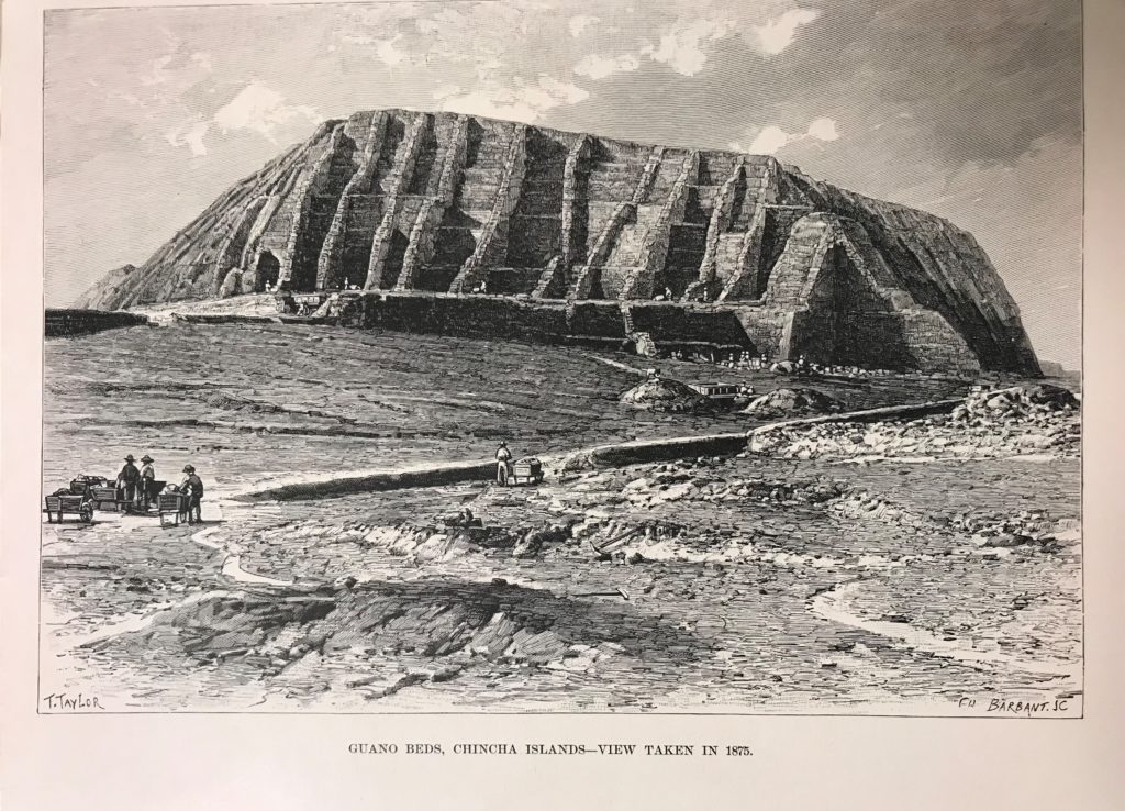
That is when a print woke me from the malaise. It was an illustration of a rather impressive stone monument, not unlike the foundation of Egyptian pyramids. Even more remarkable though was the caption beneath: GUANO BEDS, CHINCHA ISLANDS–VIEW TAKEN IN 1875.

Guano? Like bat feces guano?

So I took a moment to research. The Chincha Islands did in fact indicate guano, but from sea birds. It was from guano that saltpeter had been extracted for gun powder and fertilizer. The island was not just a coincidental find nor an attraction, but a highly lucrative mining enterprise.

Also, it was Spain’s seizure over the Chincha Islands in 1865 which led to the Spanish-South American War. As the island produced nearly 60% of Peru’s annual revenue, the occupation was an effective but antagonistic measure interpreted as a Spanish attempt to recapture its former colonies.

Whatever the intent of the Spanish occupation, they left eventually after demanding the Peruvian government apologize for their treatment of Spanish immigrants. Some consider it to their interpretation of reparations.

Even with the colonial powers gone, the guano deposits were nearly exhausted by 1874.

This print, dated 1875, illustrates a massive enterprise with significant infrastructure and people still at the yolk, lugging wheelbarrows of guano here and there.

I’m still unsure about this structure and timing of this depiction. There is a lot to speculate further on these inconsistencies. But that is history for you in its multivalent ways.

Reflections on My Initial Impression of Archiving the Rundel Latin American Map Collection

During my first week with the Rundel Latin American Map Collection Working as an archivist I handled engraved maps, articles, letters, postcards, and prints from European mapmakers and discoverers of the South America, South East Asia, and Africa. So, I unfolded these maps made primarily in the 18th century, read handwritten notes of conquistadors surveying routes through Argentina, and transport to their time. The grooves of an engraver’s trace and the biblichor overwhelm the senses. Aesthetically alone, these maps are stunning works of art, all the more powerful in person than in viewing online.

Going into this I figured that the material would be mostly of Spanish or Portuguese origin. But it surprised me to find that a great deal of the maps are French, English, and German . From a historiographical perspective this makes sense and even many of the descriptions on Rundel’s receipts reflect similar trends in that period’s mapping industry. It was unexpected though to find greater themes of trade routes, harbors, and forts in coastal regions. I wonder if there is material detailing Spanish and Portuguese in their extractive enterprises.

After the first day, I realized that this research might be more personal than expected. Coming from Azorean and Mexican descent, yet raised in the Central Valley of California, the experiences and understanding of colonialism and neocolonialism in the Americas center the context of my scholarship and identity. Yet, despite the collection’s clear relevance to my research, my position as an archivist in processing these maps and source material produces a complex feeling that could be unique platform to understand my own past.

Both as an academic and in my personal life, I try to be a diligent student regarding the struggle of my own mestizo history, California upbringing, and larger historical processes that shape who I am and where I live today. In my own research, I focus on primary sources derived from oral histories, natural environments, archeological ephemera, or other emergent methods used to uncover silences in subaltern pasts. This is not my research though. I am an archivist now. This tension between being a historian verses being an archivist and the way I will handle material will be a knot worth teasing out.

It is important, I believe, to better understand the purposes of these maps, letters, and surveys. It is difficult to ignore what they symbolize and tools they provided for settlers. I feel it is valuable as an archivist to acknowledge the role these maps played and to understand what they are as I formulate ways of processing them. I look forward to examining further the complexities.