Daily, I have regular encounters with two French ghosts in the CCEPS archive. One goes by Jacques-Nicolas Bellin and the other by his successor, Rigobert Bonne. I have never seen them but their presence is certainly felt in the maps. The whimsical part of me, perhaps a state induced by a windowless room thick with time, almost believes as if they are attempting to vigil me somewhere in their maps. They ebb and flow in my temporal moments without pretext or pattern. As hydrographers, they appear mostly on the coastlines. Just as the indigenous of Terra de Fuego, the shore is the contact zone of these merging worlds. For the colonists, it was that of mooring. For me, it is the grip of a page.
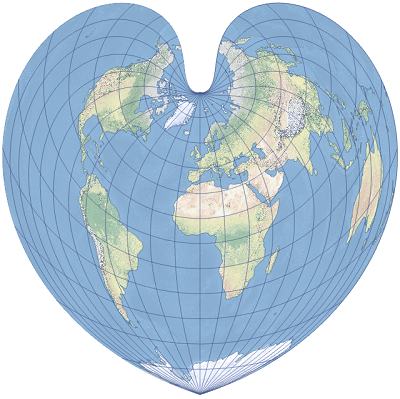
Bonne is the rather quite one, though his projections, the dépôt de la guerre or modified Flamsteed, have their say in cartographic history. In other words, his work speaks for itself. The projection articulates more accurate shaping around the prime meridian and standard parallel. It is perhaps of no small note which countries that central line passes through. Everything from that Franco-Anglo focus distorts in t-shaped dimensions, in circular contortions. Really, it looks like a heart. What is one man’s heart is another’s equal-area pseudoconic map projection. In fact, the heart was invented by Claudius Ptolemy about A.D. 100 but it was Bonne who really put it on the page. With that heart comes an overabundance of Eurocentrism. In the distortions are the “false easting” and “false northing.” It probably has no intentional implications to be fair. Still every heart has its meridian.
Aside from Bonne and his distortions and heart projections come discourses and identities I’d expect from French geographers in the Enlightenment. Party to the Encyclopédistes and the philosophes, Bellin was in the company of none other than the likes of Montesquieu, Voltaire, Rousseau, and Baron d’Holbach. Over the course of his career he contributed over 994 articles. He was a man not of the heart, but of the mind. A serious enlightenment figure, his transition to a more rigorous and positivistic approach in cartography impacted far more than just mapmaking. In this time, the most influential members of a burgeoning history profession depended on and were enchanted by the developments in mapmaking. With these technologies of land order was deployed to solve conflicts such as the Sykes-Picot line. France and the United Kingdom, by their own means, divyed up “the orient” by drawing a straight line across a map. This is mine. This is yours. Surely there won’t be any conflicts resulting from it later. The maps reflected in the interpretation of land and space for historians and their celebration/formations of national identity. The scientific approach to mapmaking directly engendered culture and evidenced it. Remember, geographers like Bellin were at the employ of the King and the navy. The ink was drawn from that well. Draw the lines were they may fall, but the picture I see is a mapmaking of colonial legacy in historiography.
Least to say, our conversations muddle and froth. Ironically, Bellin often complains. He had always found his mapmaking efforts tedious and a burden. In a way, I can listen to Bellin and almost empathize with him. He was caught in the machine of the Enlightenment juggernaut. Cartography was a means of survival based on a skillset. I wonder if he ever reflected on his impact. I wonder if he questioned what his maps might do. Bonne, he’s got heart, which makes me more suspicious of him. That sort of application seems unreachable. I find it more difficult to breach his passion. But we are so thick of time here in the archives. There is little light and less windows. We ebb and flow in this space with little pretext or pattern