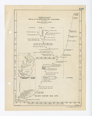
Irrigation planning led to the rapid expansion of the Boulder canal from Metropolitan Water District and government subsidized urban planners. Engineers developed plans utilizing more “creative” displays of data within the blueprints.
In the Boulder Canyon planning images, this is exemplified by the map showing the water pathways planned from just south of St. George, Utah and tracked down to Yuma, Arizona and finishing in the Gulf of California. The location was not the main interest in the axes of this chart, but rather the elevation above sea level and the rate of flow captured by the project.
What results is a diagram that emulates a meandering river but actually shows the flow of water based on elevation and rate, regardless of geographic location. The ingenuity of the Engineers utilized the decreasing elevations and the South-West orientation of the Colorado River to create this map doppelgänger, which represented important data in an eye-pleasing manner.
ARA Series: Boulder Canyon Project Series, 1948-1966. Record Group 48: Records of the Office of the Secretary of the Interior, 1826-2009. National Archives Identifier: 2292774