Post-War Canal Maintenance: Part 1

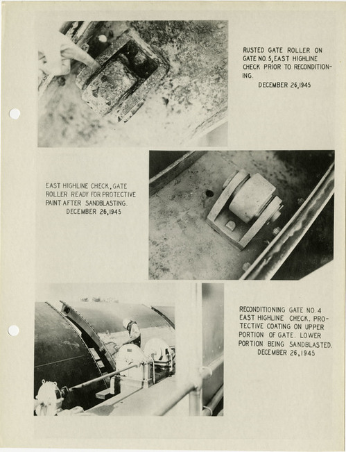
During World War 2, all non-essential maintenance on the All-American Canal was halted. By the end of the war, a large section of the banks of the canal had become overrun with vegetation such as willows, and arrow weeds. Other portions of the canal needed repainting and replacements of deteriorated metalwork. To combat these issues, an accelerated program of maintenance and rehabilitation was inaugurated in 1946. 

Below is an example of some of the rehabilitation done in 1946. Note the difference of the gate roller before and after being sandblasted. Sandblasting, addition of protective coating, and repainting made up the majority of the rehabilitation work completed. 
Thumbnail image for Reconditioning 1946.jpg
NARA Series: All-American Canal Project Histories, 1948-1954. Record Group 48: Records of the Office of the Secretary of the Interior, 1826-2009. National Archives Identifier: 2292770

Reclaimed Farm Land in the Coachella Valley

Below is a photo of flourishing corn crops in the Imperial Valley in 1946. Thanks to the All-American Canal, areas that were once barren were able to be reclaimed as farmland because of the steady water supply the canal provides.

Photos like this, as well as other farming related documents in the All-American Canal collection could be used by students to learn more about the always evolving farming communities in the Imperial Valley. They could learn not only what kinds of products were grown in the area, but how production increased and changed based on the various stages of completion of the Canal. Students can also learn about what kinds of produce were grown in the region. Students could even work with local farms to see if the produce grown in the area is still the same today!
corn crops.jpg
NARA Series: All-American Canal Project Histories, 1948-1954. Record Group 48: Records of the Office of the Secretary of the Interior, 1826-2009. National Archives Identifier: 2292770

Mysterious Relocated Cemetery

This photo of a relocated cemetery is included in the 1936 All-American Canal Project History. It can be found in Chapter 2, subsection “Construction.” While the chapter gives extensive information about the worker housing built in 1936, nothing is mentioned in this chapter about the photo of this mysterious cemetery. There is no indication of where it is specifically located, where it was previously located, or why the graves needed to be moved at all. The only information given to the location is in this photo: Potholes, California. 


Potholes was a small mining town located close to the Colorado River and Railway Lines. The small town thrived during the early 1900s. A 1981 Geological Survey indicates the Potholes Cemetery address as “County Route 24 south of Potholes & north of Bard”, however keep in mind that is likely the 1936 location, and not the original location. 


halloween post.PNG
Geological Survey Information: https://geonames.usgs.gov/apex/f?p=gnispq:3:0::NO::P3_FID:247731
NARA Series: All-American Canal Project Histories, 1948-1954. Record Group 48: Records of the Office of the Secretary of the Interior, 1826-2009. National Archives Identifier: 2292770

Graphing Before Computers

Today we take advantage of the fact that we can create multi-colored graphs with a few clicks of a mouse. Prior to computers though, graphs had to be hand drawn and colored. It can be clearly seen that colored pencils were used to fill in the various parts of the graph below. Note the small spaces where the creator accidentally colored outside the lines! Ooops! One thing that is especially impressive about this graph is how vibrant the colors still are even after over 70 years!

1944 graph.jpg
        
Series: All-American Canal Project Histories, 1948-1954. Record Group 48: Records of the Office of the Secretary of the Interior, 1826-2009. National Archives Identifier: 2292770

Happy Electronic Records Day!

Did you know that October is both American Archives Month, as well as California Archives Month!?!? Even more exciting is that today is Electronic Records Day! Today is especially exciting considering the #CLIRWater project is an electronic project. So far, approximately 1500 #CLIRWater documents will join the numerous digital files already held at NARA. Not all digital files, however, are scanned. Some documents originate as electronic files. These files are held by the the Electronic Records Division of NARA. This particular division holds over 1 billion electronic files.

Digitizing records provides numerous benefits, such as making sources more accessible to researchers, preventing damage to original records by reducing handling, and allowing for easy addition of digitized documents to posters, projects, and presentations. Below is a poster celebrating the 2018 California Archives Month. Included on the poster are digitized photos of Hearst Castle. 
Thumbnail image for archives month.jpeg

Date Farm Weather Reports

During the construction of the All-American Canal, in addition to tracking the production of produce grown in the Imperial Valley, regular weather reports were also taken. Below is a 1943 Weather Condition Report from the Date Gardens located in Indio, CA. This is an exciting find for researchers looking to examine global warming in the Imperial Valley. These weather reports could also be compared to the agricultural production reports mentioned in a previous blog post to see if there is a correlation between weather and produce production. There are also other great finds hidden away in the Project Histories collection that are just waiting to be discovered! 

048-18-0010-051-A.jpgSeries: All-American Canal Project Histories, 1948-1954. Record Group 48: Records of the Office of the Secretary of the Interior, 1826-2009. National Archives Identifier: 2292770

1942 Visitors to the Canal

Included in every All-American Canal Project History is a list of visitors to the Canal during the construction process. Below is the second half of the 1942 list of visitors. The closer to completion the Canal became, the shorter the list of visitors became. Early lists of visitors were several pages long, whereas the 1942 list is only two pages long. Note the wide range of titles and places of business that these visitors represent. The first half of the list also includes a United States Senator from Arizona, an Assistant Forest Chief from the Forest Service, and an Irrigation Engineer from UCLA.

048-18-0009-012-TH.jpg
Series: All-American Canal Project Histories, 1948-1954. Record Group 48: Records of the Office of the Secretary of the Interior, 1826-2009. National Archives Identifier: 2292770

Celebrating the Opening of the Canal with King Neptune

In 1940, a grand celebration was held to commemorate the opening
of the All-American Canal. This celebration was not to celebrate the completion
of the canal, but rather to celebrate the first use of the completed parts of the canal. A completed, and filled, section of the canal is where the celebration took
place. This particular section is called the East Highland Canal. Water in this photo was
initially “ponded” at the East Highland Turnout so that way the initial delivery
of water could be made the day of the celebration. Water in the photos would
eventually flow out to the Imperial Valley after traveling through the canal.
Celebration photos below show King Neptune and his court of lovely women
floating to the celebration on a decorated raft, as well as the Commissioner of
Reclamation (John C. Page) giving an opening address which kicked off the
celebration. It would be two more years before the canal would be completed. Reports
on the Canal continue past its completion in 1942 and through to 1954. Later reports
look closer at the functionality and economic benefits of the Canal.

all-american canal celebration 1940.jpg

Series: All-American Canal Project Histories, 1948-1954. Record Group 48: Records of the Office of the Secretary of the Interior, 1826-2009. National Archives Identifier: 2292770

1,000th Scanned Document!!!!

Today marks quite a milestone! This is the 1,000th
page digitized at NARA for the CLIRWater project. People often wonder why more
collections are not made available to researchers digitally. It has taken approximately
180 hours to scan these 1,000 documents. The All-American Canal Project Histories
1934-1954 collection is made up of 2 linear feet, and 10 linear inches of
documents. These 1,000 pages are barely one-third of the relatively small
collection. It will likely take another 350-400 hours to complete the
digitization of the documents in this collection. These hours do not
even include the scanning of the over-sized documents mentioned in last week’s
blog post. There are also two additional NARA collections to be scanned for the
CLIRWater project, and each is slightly bigger than the All-American Canal
Project Histories 1934-1954 collection. It takes a considerable amount of costly
labor, as well as specialized equipment and dedicated digital storage, to bring
collections like these to the masses in a digital form. This is precisely why funding for
projects like the CLIRWater project is so precious. 


1000th scan.jpg

Series: All-American Canal Project Histories,
1948-1954. Record Group 48: Records of the Office of the Secretary of the
Interior, 1826-2009. National Archives Identifier: 2292770

Over-sized Items

     When the largest document a scanner can accommodate is
12.5 inches by 17.5 inches, there are bound to be documents that are too large
and must be scanned on other equipment. So far, there have been approximately 200
over-sized items in the All American Canal Project Histories Collection. This
means that for about every five items which fit in the Epson Expression 10000
XL scanner, about one of them will not fit. The photo below is an example of a
VERY over-sized item. Measuring approximately 6.5 feet wide, and 10.5 inches
tall, this map will need to be scanned on specialized equipment. As you can
see, by just taking a panoramic photograph of the map, the dimensions and details
are distorted and some of the information is lost. This is why these items are
set aside until they can be scanned on either a scanner with a larger scanning
surface, or a scanner which allows the feeding through of long documents. Scanning
of this map will likely be completed on an engineering scanner. Engineering
scanners essentially feed through a document while scanning it at the same
time. All oversized items in this collection are being noted so that way they
can be scanned together when all of the other smaller documents are finished
being scanned.

 
1940 oversize map.jpeg
 

Series: All-American Canal Project Histories,
1948-1954. Record Group 48: Records of the Office of the Secretary of the
Interior, 1826-2009. National Archives Identifier: 2292770